What did Robert Burns think of Elgin?
And did Bonnie Prince Charlie spend several nights in the town because he took a liking to the place?
Answers to these questions and others came up when Moray culture and history featured in the History Scotland: Hidden Histories podcast for 14 January 2018.
One of the aims of the podcast is to explore visitor attractions which could be described as a bit off the beaten track.
Well-known local figure, Jim Royan, gives a general introduction to Moray.
He then took presenter, Neil McLennan, on a tour of the centre of Elgin, focusing particularly on the Castle-Cathedral-Cashmere trail. The final part of the hour-long programme featured Moray’s own Fire Festival, the Burning of the Clavie, held in Burghead.
This article looks at the general Moray part and the section of the podcast which involved a wander through Elgin. We’ll look at the Burning of the Clavie in a separate article.
Moray is a triangular-shaped county.
According to Jim Royan, Moray is unique and yet not well known.
Moray is like Scotland in miniature. The coast of Moray is about 50 miles from the top of Ben Macdhui, which is the second-highest mountain in Scotland.
Moray has mountains and coast, moor and agricultural land, with two of Scotland’s most impressive rivers – the Spey and the Findhorn. There’s something for everyone from an activities point of view. Jim makes specific mention of golfing and fishing.
Perhaps controversially, Jim describes Elgin as the epicentre of Moray, from which everything else spans out.
One of the most infamous figures in Scottish history came from Moray.
Patrick Sellar (1780 – 1851) was born in Moray and is buried in Elgin Cathedral. His father was a lawyer in Moray and Sellar himself trained as a lawyer.
His infamy comes from the part he played in the Highland Clearances, as the Duke of Sutherland’s factor.
In the early 1800s, Patrick Sellar was commuting from Burghead to Helmsdale by boat.
Jim Royan gives a geographical history of the coastal part of Moray.
He does this from a position perhaps somewhere on the A96, east of Alves.
From this point, they’re looking northwards, with a view which includes Duffus village and Gordonstoun School, the aerial masts at Burghead, and Lossiemouth.
The same view around 500 A.D. would have you looking towards an island. Burghead would be visible at the west side and Covesea (with its modern-day lighthouse) at the east. There would then be a sea inlet where Silver Sands caravan park is now. Further east would be the rocky outcrop of Coulard Bank – part of the Lossiemouth of today.
A transformation of this landscape occurred over the next 500 years or so.
Longshore drift – to do with effect of the wind, shifting sands and currents – caused the River Findhorn to change course. The narrowest points began to silt up and the deposits were moved around by the tides and winds. These deposits consolidated over years and rich agricultural land formed.
A similar phenomenon emerged between the mainland of Moray and Coulard Bank. This process started to form a sea loch at Lossiemouth. This was the only entrance and exit. At the head of that loch, Spynie Palace became the port of Elgin. A lot of commerce began to develop between Moray and the low countries. This whole area was transformed.
Picking out one particular event from that period, Jim Royan refers to August 1040. At that time, in this view, we might have been able to pick out the 5 ships of King Duncan arriving to take on Macbeth. According to Jim, the battle between Duncan and Macbeth took place at Pitgaveny, just outside Elgin.
Eventually, that one remaining sea passage disappeared. Sea loch became land-locked and was transformed into a freshwater loch (Spynie Loch) – of probably about 3000 acres – in the 1600s – 1700s.
The 1700s and 1800s were a period of wealthy landowners.
Moray has a micro-climate and good levels of fertility. It had developed prime agricultural land through the processes described above.
The Brander-Dunbars of Pitgaveny were agricultural reformers. Across Spynie loch, at Gordonstoun, the Gordon-Duffs were hunting, shooting and fishing types. They wanted to keep the loch for fishing and wild fowling. Eventually, they realised this asset could better be realised by draining the land. They got in touch with Thomas Telford, the famous Scottish civil engineer, and he took on the task of draining the freshwater loch to release rich agricultural land.
There was apparently a pedestrian ferry that went from Myreside to Salterhill.
(Myreside is about 1 mile north of Elgin, close to the west side of the modern-day road to Lossiemouth; Salterhill is about 2 miles further north than Myreside).
Ultimately, compensation had to be paid to the Gordon-Duffs for the loss of the ferry and, presumably, the redundancy costs of the ferryman.
Most of RAF Lossiemouth is built on land that was previously under water.
The canal system in the area (e.g. Spynie Canal) has been crucial to the agricultural base of Moray.
How much land was reclaimed overall?
Well – with the Laich of Moray stretching from Brodie in the west to Fochabers in the east – probably about 30,000 acres or so.
The programme then shifts its focus to the town of Elgin.
Neil and Jim are standing at the start of the “Castle to Cathedral to Cashmere Trail”. This started as a working title but ended up as the name of the project.
There is an orientation point in the centre of Elgin that helps people find things they may have otherwise missed. There are also signposts to direct people to the key points outwith Elgin.
The start of the Castle to Cathedral to Cashmere Trail is at Ladyhill.
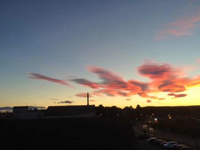
For those familiar with the A96 through Elgin, it has a tall, thin tower, topped with a statue – a monument, put there in 1832, to honour the 5th Duke of Gordon, who was an agricultural reformer.
But the monument does not hint at the original use of Ladyhill.
If you stand at the top of Ladyhill, looking east towards the centre of Elgin, the skyline is dominated by St Giles Church, down the High Street. This part is the “planned” burgh of medieval Elgin and represents 1,000 years of history.
The hilltop features the remains of the second Elgin castle.
The first one would have been built of timber and turf. It was knocked down around the early 1100s. The castle had motte and bailey-type architecture for the safekeeping of the inhabitants of Elgin.
Going back to 1040 – when Macbeth mortally wounded Duncan – Duncan was taken to Elgin Castle (or somewhere near the Cathedral) where he died. His body was then taken to Iona for burial.
Looking at it another way, Elgin Castle was the original “Balmoral”.
People came – say, in their Easter Holidays – for hunting, shooting and fishing.
Moray offered wealth amidst fertile land – it was a place you could come for a “safe” break.
This part of Scotland dominated power at that time.
Continuing with the view from Ladyhill, to the south, you can see the foothills of the Grampians and Speyside. To the west, the Findhorn valley is only about 8 miles away. In the foreground is Dr Gray’s Hospital built in the early 1800s. A chap who had made his fortune with the East India Company left a legacy to the town which enabled the construction of the original building.
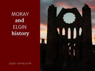
Again looking east, through trees, you can see the two towers of Elgin Cathedral.
A bench at the top of Ladyhill commemorates Robert Burns.
He came through Elgin on his north tour, with his good friend, Willie Nicol. He didn’t stay long. He had a meal but was not very complimentary about it.
He had the good grace to say that the Cathedral was a magnificent piece of architecture – though not quite as good as the one in Melrose.
By the late 1400s, some shape was emerging in the architecture of central Elgin.
There was a degree of common forms of architecture. The Plainstones – at the current centre of the town – emerged in the 1700s.
The Castle to Cathedral to Cashmere Trail has a number of interpretation boards dotted along its length.
QR codes provide links to even more information on the website. Some of the links are to audio of voices of people from the past.
Another feature of the trail in Elgin centre is 3 public artworks.
Each of these has been controversial to some extent.
Perhaps this is because it always takes folk a wee while to get used to “transformational” projects.
The process was put out to tender to artists across Scotland and they received 11 responses. This was then shortlisted to four. Maquettes were produced of them. They were put out to public exhibition and the 3 that came out on top were commissioned. It was possible to make the third one because money was left over from the first two…
They were unveiled by the Princess Royal on 07 March 2017.
Descending from Ladyhill, heading east, the most westerly of the artworks (visible from the A96 as it diverts from its line towards the Plainstones) is to be seen.
The “Wolf of Badenoch” was a man who played a critical role in the history of Elgin, Moray and the North.
He was the illegitimate son of Robert II.
He sent his wife back to Ross (she was Countess of Ross) and he took in a woman named Mariota as his cohabitee. As a result, the Catholic church excommunicated him.
He was a bit of a villain already and, from his castle at Lochindorb on Dava Moor, he marched with his small band of men and burned down Elgin Cathedral on 16 June 1390.
The Wolf of Badenoch statue is illuminated at night in different colours.
The idea is to use the Wolf of Badenoch as a “taster” for the building he destroyed – as a means to encourage people to visit the Cathedral, whether they are local to Moray or not.
Continuing along Elgin High Street, before reaching the pedestrianised area of the Plainstones, our guides see scaffolding on various buildings.
This has been erected as part of the High Street Conservation Area Regeneration Fund.
Within the conservation area, owners can apply for an intervention from the fund.
At the time of the podcast, an early 1800s building was being restored to its former glory.
Jim Royan then refers to his own butcher’s business, founded in 1850.
When seeking to commemorate its 150th anniversary, they focused on the fact it spanned 3 centuries on Elgin High Street.
They set up photo montages on the side of the building, emphasising their integration into the community and celebrating 150 years of agriculture in Moray. As Jim Royan says,
“Society does not exist without turning the soil.”
Images include: the view east from Lossiemouth to Buckie and the Bin of Cullen; and west from Findhorn Bay to Ben Wyvis.
Aviation’s role in Moray is also referenced by images of Nimrod and Buccaneer aircraft.
As Moray is “Malt Whisky Country”, that also features.
Jim Royan also refers to the fact that there are so many family-founded businesses in Moray: e.g. Walkers; Johnstons; Baxters; and Forsyths.
Still in this same section of the High Street, we find Elgin’s link to Bonnie Prince Charlie.
The Thunderton Hotel (its modern name) at Thunderton Place is where Prince Charles Edward Stuart is thought to have stayed several nights prior to his defeat at the battle of Culloden. He was suffering from flu at the time.
The building is currently under restoration, having gone through many incarnations as pubs and hotels over the years.
It’s only a short distance from there to by far the most controversial of the 3 public artworks.
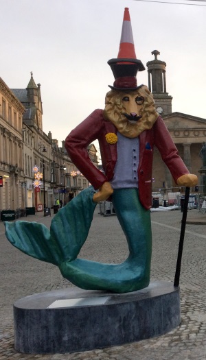
At the western edge of the Plainstones stands the Dandy Lion.
The background to this brightly-coloured 10-foot edifice dates from the Victorian era.
In the central Elgin of that time, people met up and business was done. The artwork tries to capture mood of this period in Elgin’s history.
It is part animal, part man, part fish.
The dandies of Victorian times were its poseurs. The top hat, monocle and cane depict this.
The lion’s head is there because he is the “dandy lion”. A dandelion is known to us as a wildflower and he actually has a dandelion in his lapel.
If you were a farm servant in the days when there were the Feeing Markets, farm servants could change jobs after the Spring work was finished and after harvest was in. On a specified date, these farmworkers used to come to the Plainstones in Elgin. They would have on their best suit on and look as tall and as strong as they possibly could – and they would have a dandelion in their lapel. That gave out the message: “I’m free and available for work”.
The Dandy Lion’s clothing reflects the weaving and mill tradition of Elgin – something carried on by Johnstons today.
The fish tail of the Dandy Lion alludes to the fish wives from Hopeman, Burghead and Lossiemouth who used to come to the Plainstones to sell their fish.
So, as explained by Jim Royan, there is a legitimacy in the statue but there was a “slight division of opinion” amongst the population of Moray when they saw it first of all.
The week after the Dandy Lion was installed, it was reported on the BBC and STV, and in The Times, The Sun and all of the Scottish national newspapers.
No doubt referring to the cost saving compared to a bespoke marketing campaign with similar “success” in promoting the trail and the artworks, Jim Royan’s comment is: ““Job done”, as far as we were concerned!”
The drummer of Elgin is the most easterly of the three artworks, beside St Giles’ Church.
Still on the plainstones, just behind the Muckle Cross, it is probably the “most favourite and least controversial” of the 3 public art objects.
The town drummer presented here was called William. He did the job for 50 years. It involved going up and down the closes in the morning to get people up to go and work in the factories – the tanneries and woollen mills. Getting up time was originally 4am but it later changed to 5am.
There was a similar routine in the evenings, if there was a curfew required.
This piece is by Alan Heriot, who comes from Dalkeith, near Edinburgh. Apart from the drummer, there is a wee boy running behind him, trying to replicate what the drummer is doing. The dog in the piece is based on Alan Heriot’s own dog, which had died about 3 years earlier.
At the east end of the High Street are the Moray Council buildings and Elgin Museum.
Elgin Museum is an important feature of the history of Elgin.
It is an independently-run museum by a group of enthusiastic volunteers. There are some wonderful collections within the museum and it is incorporated as part of the Castle – Cathedral – Cashmere Trail.
Neil McLennan clearly enjoyed his day with Jim Royan.
A day spent going round Elgin and finding out more about Moray’s history, with particular emphasis on the CCC trail, running right through the centre of Elgin and bringing together the different elements of history – from the Castle to the Cathedral to Cashmere.
Don’t forget the wealth of materials available online allowing you to discover Moray’s rich past.
Like Jim, we hope it will inspire you to visit Moray – to meet its friendly folk and enjoy their warm hospitality.


 When is the Best Time to Contact a Solicitor for Help?